
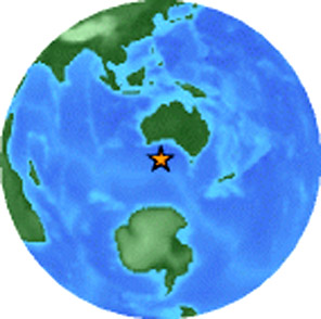
5.1 Earthquake recorded off the South Australian coast by United States Geological Survey’s Earthquake Hazards Program
A 5.1 magnitude earthquake was recorded off the South Australian coast on Monday 5 April at 11.23pm UTC within impact distance of the Great Australian Bight Marine Park.
The Great Australian Bight Marine National Park in South Australia and in Western Australia is located 918 km west of Adelaide.
The Australian Government manages an estate of marine protected areas (MPA) in the Bight that are Commonwealth reserves under the Environment Protection and Biodiversity Conservation Act 1999 (EPBC Act) .
The offshore earthquake was 1470 km (910 miles) SW of ADELAIDE South Australia, 1005 km (630 miles) SSE of Esperance, Western Australia, 1035 km (650 miles) SSE of Albany, Western Australia, and 1425 km (890 miles) SSE of PERTH, Western Australia.

Compressional wave from the earthquake location to points around the globe. Images: USGS
The quake off the South Australian coast was much closer to the surface at only 10km (6.2 miles) depth compared to the 46 km deep Sumatra earthquake recorded the following day at 7.8 magnitude also by the United States Geological Survey’s Earthquake Hazards Program
Theoretical P-Wave Travel Times
Magnitude 5.1 SOUTH OF AUSTRALIA Monday, April 05, 2010 at 11:23:41 UTC
The map (above) shows the predicted (theoretical) travel times, in minutes, of the compressional (P) wave from the earthquake location to points around the globe. The travel times are computed using the spherically-symmetric IASP91 reference earth velocity model. The heavy black lines shown are the approximate distances to the P-wave shadow zone (103 to 140 degrees).
Haiti warned to brace for another big quake | Reuters
More than 50 aftershocks, including one measuring 5.9 magnitude, shook Port-au-Prince after last month’s quake. The U.S. Geological Survey says the aftershock sequence will continue for months, “if not years”, and damaging earthquakes will remain possible in the coming months.
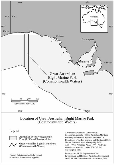
Location of the Great Australian Bight Marine Park
GREAT AUSTRALIAN BIGHT MARINE PARK (COMMONWEALTH WATERS) MANAGEMENT PLAN 2005–2012
Excerpt
“The area commonly referred to as the Great Australian Bight Marine Park is made up of adjoining South Australian and Commonwealth protected areas.
The State Marine Park, in the State (coastal) waters of the Bight, combines a whale sanctuary established under the Fisheries Act 1982 (SA) and a marine national park established under the National Parks and Wildlife Act 1972 (SA).
The adjoining Great Australian Bight Marine Park (Commonwealth Waters) is a Commonwealth reserve established under the National Parks and Wildlife Conservation Act 1975, which was replaced on 16 July 2000 by the Environment Protection and Biodiversity Conservation Act 1999 (EPBC Act)”.
Petroleum (Submerged Lands) Act 1967
Marine Mammal Protection Zone
Offshore Minerals Act 1994
Sea Installations Act 1987
Environment Protection (Sea Dumping) Act 1981
Ceduna Sub basin oil acreages and wildlife park with location map inset
The Bight Basin – Geoscience Australia
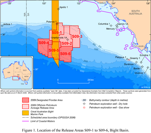
The six new Release Areas offered in 2009 are located in the northern central part of the sub-basinThe six blocks range in size from 6000 to 6400 square kilometres.
The three inboard blocks (Release Areas S09-1 to 3) are in water depths of 130 to 1600 metres.The three outer blocks (Release Areas S09-4 to 6) are in water depths from 1200 to 4600 metres.
The Ceduna Sub-basin is in the eastern part of the Bight Basin and contains up to 15 kilometres of Middle Jurassic to latest Cretaceous rocks.
The Ceduna Sub-basin has been the focus of the most recent exploration effort which, for a number of reasons, has not met with success.

Composite seismic line (GA 199-05 - DWGAB-06 - HRGAB-119) across the Ceduna Sub-basin. Supersequences are labelled.

Oil-rig-leak-fuel-into-the east Timor Sea off WA, spewing oil and gas at at least 400 barrels a day for 10 weeks
Australia West Atlas oil well catches fire
Full article here
The oil well which has caused a massive spill in the Timor Sea, off the north west coast of Australia, caught fire on Sunday…..
PTTEP Australasia, a Thai-based energy company which operates the well, said the fire broke out as it made another attempt to plug the underwater leak….
For more than 10 weeks the leak has been spewing oil and gas at at least 400 barrels a day…..
After a 10-week leak, West atlas drilling rig and the Montara wellhead platform caught fire on Sunday.
When oil, gas and condensate began seeping into the Timor Sea PTTEP estimated it would take 50 days to plug the well in an area described by Tourism Australia as “one of the world’s last true wilderness areas.”
Three previous attempts by PTTEP Australasia to plug the leak, 2.5km below the sea bed, by pumping it full of heavy mud, have failed. Photograph: Debra Glasgow/WWF. Caption: Guardian UK.

10 week Montara oil platform blowout and spill - google image view
Cumulative oil slick “footprint” resulting from the 10-week Montara oil platform blowout and spill that occurred in the Timor Sea off Western Australia in 2009; superimposed on the Gulf coast of Florida for scale.
Based on SkyTruth analysis of MODIS imagery from the Terra and Aqua satellites operated by NASA.
The cumulative area impacted by oil slicks and sheen over the course of the Timor Sea spill was slightly over 22,000 square miles, an area nearly the size of West Virginia (see the sequence of images in this gallery entitled Montara Spill – Cumulative Oil Slick Impact”).
Possibly related posts
Top 5 Ways to Cause a Man-Made Earthquake
Wired Science – by Alexis Madrigal
According to a major analysis by Russian scientists, “Few will deny that there is a relationship between hydrocarbon recovery and seismic activity…” They caution that in regions where tectonic activity is already high, extracting oil and natural gas could trigger strong quakes…..
Australia’s shame – the Timor Sea oil spill disaster in pictures
The Northern Myth – by Bob Gosford
The political response has been limited to hand-wringing stop-gap measures and to paying for a series of failed attempts to plug the spill and some apparently ineffective mopping-up operations…..
Australia, PTTEP to Probe Timor Sea Oil Spill, Blaze (Update3)
Bloomberg – by James Paton
Australia will set up an inquiry this week into a leaking oil well that may have spewed 30,000 barrels of oil into the Timor Sea, prompting calls for a freeze on new exploration permits from environmentalists.
WWF-Australia called the spill an “unfolding environmental disaster” and reported seeing dolphins, birds and turtles in the oil slick area.
“The accident shouldn’t have happened in the first place, so that is a stuff up,” PTTEP Australasia’s Martins told ABC Radio. “In terms of the response, I think that has been world class.”
World’s worst environmental disasters
MSN Environment Editor – Tom Levitt
Twenty years ago, the Exxon Valdez oil tanker disaster spilled more than 11m gallons of crude oil off the Alaskan coast, devastating local marine wildlife.
Strong winds hampered attempts by the coastguard to clean up the resulting oil slick which eventually contaminated about 1,300 miles (2,080 km) of coastline.
It caused a tragic amount of damage to the natural environment. Around 250,000 seabirds, 2,800 sea otters, 300 harbour seals, 250 bald eagles and 20 or more killer whales died as a result.
Discover more from Coober Pedy Regional Times
Subscribe to get the latest posts sent to your email.
Categories: GENERAL News

It is disturbing to realise that the recent earthquake so close to the South Australian coast has not received much public interest. It should have.
In the recent Chilean earthquake, a critical emergency problem was in dealing with that country’s military base, and nuclear reactor. The urgency to remove uranium stockpiles was a vital and dangerous part of the government’s response.
Now, admittedly, Chile’s uranium stores were of Highly Enriched uUanium, (HEU) , which we don’t have, in South Australia. But still, this was a wake up call to the dangers of Australia getting any deeper into the nuclear fuel cycle. (And, we might question the morality of Australia selling to others a resource that inevitably is developed into Highly Enriched Uranium.)
Highly Enriched Uranium must be stored and shipped in certain geometrical configurations — long, flat sheets, for instance — so that it does not spontaneously start a nuclear chain reaction, spewing out heat and radioactive by-products. Chile had to transport this very unstable material very fast, through areas at risk of tsunami.
What I don’t understand is, if it’s a National Park reserve for marine life, firstly how do you contain them in a particular strip when they are migratory and how come you can put oil and gas drilling rigs on top of the same area?
Isn’t that a bit confusing and counter productive to making it a Marine Park? What if there’s an earthquake and an oil spill because of teh drilling?
Is this another one of those tricky bits of paper warfare so typical of our governments?
This is a shocker as we live on that coastline and considered the area was protected by conservation. Does anyone know if these areas designated in 2009 are operating. If so it’s a shame we didn’t get to hear about this plan to put gas and oil just off our coastline before the state election. This is scarey stuff.
It is typical of the tricky, sticky deals being done that really don’t have conservation in mind at all.
All these greedy processes are earthquake prone and make you wonder if the powers that be are pulling our legs while they quarry everythingin sight regardless of the impact on both conservation and communities.
We are pleased to see that some media are alert enough to inform the people of that which seems deliberately concealed in hard to find places.
Can see it’s all available but why would we be looking for this? It’s ok to report BIG stuff, but what about our home turf? We are being failed from every angle.
can any body help me i am a retired driver
based at NSC Zetaland Sydney
As driver for department defences
I am trying to locate my former work mates
can any body assist me
the motor pool was disbanded in 1995
e mail
herveybayqld@hotmail.com
Regards
Ian
Small Earthquake at Glenalta (Adelaide Hills) 11.27 pm vibrations traveled southwards from the north, and (of course) from underground. Did anyone else feel It?
We’ve been hearing about it James, but too busy checking on the all previous warnings around the southern areas.
This one offshore is a real worry. Imagine that one under Mt. Barker?
Haiti got the same warning two years in advance, but they kept on taking out the minerals and upsetting the balance.
.
Sorry to say this but our government is f*d in the head to let mining companies and developer near these faultlines and near people.
There’s another good story up the top on right hand side which says it all dated 2008. We put it on facebook. How much warning do these penpushers need? This country’s gone totally crazy.