

3.8 Earthquake centred at Mt. Barker said to be caused by tectonic plate movement and pressure on the plates resulted in a 20 second earth tremor
* Newcastle 1989
* Flinders Ranges 2003
* Woomera:Torrens Fault
* Olympic Dam :Mashers Fault
* National Radioactive Waste Repository
* Mt. Barker – Adelaide: with a popluation of approximately one million people experienced an earth tremor or quake registering a magnitude of 3.8, stemming from an epicentre in the Adelaide Hills, according to Geoscience Australia.
No damages were reported although the incident has clearly shaken the public across the country, with individuals seeking out information on faultlines or seismic activity in their region, which may pose an unexpected danger to home and families.
Many warnings regarding the potential dangers of increased seismic activity particularly in the southern parts of Australia have been well published over the past several years. In fact as far back as 2003 and again in 2008.
The Mount Lofty Ranges are a fault bound range to the east of the city of Adelaide, the large scale tectonic morphology of which is dominated by fault-scarps

The Mount Lofty Ranges are a fault bound range to the east of the city of Adelaide, the large scale tectonic morphology of which is dominated by fault-scarps
Pictured is the Adelaide-Murray Bridge region, showing a prominent fault range.
The western boundary of the ranges is defined by the the Para, Eden-Burnside, Clarendon and Willunga Faults, while the eastern boundary is defined by the Palmer and Bremer Faults.
Image created using the DENR 100m DEM, using RiverTools. Credit
Geomorphology or plate tectonics around Adelaide Hills and Mount Lofty Ranges
“All the fault zones are still active today, along with the rest of the ranges, and minor earthquakes are relatively common. Larger quakes in the southern ranges are fairly rare: the last to hit a major centre was the March 1, 1954 earthquake in Adelaide itself, measuring 5.5 on the Richter scale”.
Wikipedia
Physiography including the Eden Fault Zone and the Torrens Graben
Absolute Astronomy
The seismicity of the Adelaide Geosyncline, South Australia
The population center of Adelaide has the highest earthquake risk of any capital city in Australia. The 1954 (ML 5) Adelaide earthquake involved 30,000 insurance claims totalling $11 million (U.S. currency). Epicenters for microearthquakes in the Adelaide region show a correlation with known faults. Seismicity here appears to be associated with normal block faulting of the St. Vincent Gulf Graben structure.
S. A. GREENHALGH and R. SINGH
NEWCASTLE 1989:
The 1989 Newcastle quake, magnitude 5.6 killed 13 people and injured more than 160 others, incurring a damage bill estimated at $4 billion.
The effects of the Newcastle quake were felt over an area of approximately 200,000 square kilometres in New South Wales, with isolated reports of movement in areas up to 800 kilometres from Newcastle.

"Fallout" area of 1989 Newcastle earthquake - magnitude 5.6
The damage to buildings and facilities was reported over an area of 9,000 square kilometres. Photo credit
A significant warning for Australia in September 2008 when Associate Professor Malcolm Wallace from the School of Earth Sciences at the University of Melbourne said that two separate geological studies had concluded that an area from Adelaide to south-east Victoria is seismically active and the next ‘big one’ could endanger lives and infrastructure”.
Professor Wallace also stated that in South Australia, the area between Quorn and Leigh Creek has the highest number of seismic events considered to be related to zones of crustal weakness.
In South Australia, particularly the Flinder Ranges, seismic activity is generated by tectonic plates pushing up against each other on a daily basis, so it is critically important that scientists and emergency management agencies know of their whereabouts and the potential risks they pose – this is where geoscientists play a crucial role.”

Hypocenters of earthquakes recorded by the Flinders Ranges temporary deployment
Monitoring of Earthquakes in the Flinders Ranges SA using a temporary seismometer deployment by staff at Geoscience Australia and David Love of PIRSA.
Earthquakes recorded for For the period 28/9/03 to 31/12/03, hypocentres for 194 local and regional earthquakes were determined.
A comparison of the GA and Adelaide (ADE) catalogues (without regard to position) showed that out of the first Goescience Australia list of:
175 local events:8 listed as quarry blast by ADE
47 located by ADE
10 events from Innamincka sequence (induced by well injection)
39 not located by ADE because too few stations
69 ignored or not recognised by ADE in scanning stage
3 possible errors, and smaller quarry blasts
2 uncertain”
The largest earthquake (below) recorded during the course of the experiment, which was widely felt near Hawker, SA, was the ML 3.9 (GA’s original estimate was ML 4.2)
”]”]
WOOMERA: Torrens Fault
The following year in 2004 Sandra Kanck, Leader of the South Australian Democrats and Member of the Legislative Council warned that the earthquake risk was too high for the proposed nuclear waste dump at Woomera in South Australia’s Far North.
At an ARPANSA forum on the 26 February 2004, Ms Kanck called for the shelving of the Commonwealth’s plan to use the area for a national waste dump stating that the Torrens Lineament fault runs from Kangaroo Island to Torrens Lake and right passed the proposed site, and is classified as a medium risk on the earthquake hazard map of South Australia.
“It is also in breach of the site selection criteria that the chosen site be located away from any known or anticipated seismic, tectonic or volcanic activity which could compromise the stability of the site” , said Ms Kanck.
“Beachport had an earthquake in 1897 that registered 6.5, Warooka, on Yorke Peninsula, had one in 1902 in which two people died and Minnipa on Eyre Peninsula has a quake measuring 5 on the richter scale in 1999.

Figure 2 Within the Woomera Restricted Area is "Mashers Fault" running directly through the orebody at Olympic Dam. The NE-SW-trending Mashers Fault is mapped as having a total length of 35 km. The "Torrens Fault" runs south - north west, originating at Kangaroo Island. Map credit: Edward Cranswick
“If earthquakes such as these can occur in areas that are considered to be of low risk, and, in the case of Warooka and Beachport, could be felt in Adelaide, the proposed Woomera site cannot possibly satisfy the Federal Government’s own guidelines.
“It is irresponsible for the Commonwealth to attempt to locate a nuclear waste dump near the same fault line that rocked Adelaide with a 5.4 quake on the 28th of February 1954,” said Ms Kanck.
OLYMPIC DAM: Mashers Fault
Mashers Fault and the Seismicity Anticipated to be Stimulated by the Proposed Open Pit Mine at Olympic Dam
By: Edward Cranswick (30DEC2009) REVISED* Public Seismic Network (Geophysicist, US Geological Survey, resigned)

Figure 3 Mashers Fault schematic SSE-NNW cross-section through the Olympic Dam ore body, no vertical exaggeration
Abstract: The proposed excavation at Olympic Dam of one of the largest open pit mines on Earth, 4.1 km long, 3.5 km wide, 1 km deep, at a bend in the steeply dipping, 35-km-long Mashers Fault, and the associated perturbation of the local groundwater pore pressures in a region of horizontal compressive stress would most likely stimulate local seismicity.

Figure 4 Map of Olympic Dam showing existing underground mine and outline of the proposed open pit in bold black, the potentiometric contours (labeled by elevation, m, above sea-level) in blue, and the trace of the NE-SW Mashers Fault in yellow (the eastern-most 5 km have been truncated). Black arrows indicate the principal horizontal stress direction (Bunger et al. 2008)
Faulting, perhaps related to variations of pore pressure, has occurred intermittently on structures in Australia that are difficult to recognise, and open pit mines have caused earthquakes in other countries.
Removing 1 km of rock at Olympic Dam would reduce the vertical stress by ~25 MPa, increase the deviatoric stress and facilitate thrust-type faulting in the vicinity of the open pit, and possibly stimulate strike-slip failure on the Mashers Fault, triggered by the extensive pumping and disposal of ground water.
[“potentiometric contours” in Figure 4 refers to contours of water table with respect to sea level]
Relatively small (magnitude <6), local earthquakes might damage the Tailings Storage Facilities and release their radioactive tailings to contaminate ground and surface waters and be transported throughout Australia by dust storms.
Figures 2-4 are modified from figures that are part of the Olympic Dam Expansion Draft Environmental Impact Statement 2009 (ODXdEIS <http://www.bhpbilliton.com/bb/odxEis.jsp )
Introduction: Broken Hill Proprietary (BHP Billiton) currently owns and operates the existing underground copper-uranium-gold-silver Olympic Dam mine (coordinates: –30.44°, +136.87°) 10 km north of Roxby Downs in South Australia (Figure 1).
The company has proposed in their Olympic Dam Expansion Draft Environmental Impact Statement 2009 (ODXdEIS; BHP Billiton 2009) to expand the mining operation over a period of 40 years and create an open pit mine 4.1 km long, 3.5 km wide, 1 km deep – making it one of the largest open pit mines on Earth.
The Olympic Dam ore body is a hematite breccia within the basement of Palaeoproterozoic and Mesoproterozoic crystalline rocks that are unconformably overlain by ~300 m of Neoproterozoic to Cambrian age, flat-lying sedimentary rocks of the Stuart Shelf and a veneer of surficial deposits on the eastern margin of the Gawler Craton (Reynolds 2001; see Figures 2 & 3). The mined ore is ground into particles and treated with acid to dissolve and remove copper, uranium, gold and silver, and the resulting tailings are a slurry that is pumped to the Tailings Storage Facility (TSF). There the tailings solids are allowed to settle and the liquid component is removed by evaporation and seepage into the surficial layer of sands and clays (~3 m thick) and the underlying shallow aquifer of the Andamooka Limestone, and some excess liquid drains into evaporation ponds (ODXdEIS).
Next to the ore body, the most prominent geological structure at Olympic Dam is the 35-km-long Mashers Fault that passes through the middle of the ore body and the proposed pit (Figures 2, 3, 4). The excavation of the open pit mine and the associated perturbation of the local groundwater pore pressures would most likely stimulate some level of seismicity in the vicinity of the mine, and possibly slip on the Masher Fault itself. I use the term “stimulate” as defined by McGarr et al. (2002):
‘“induced” describes seismicity resulting from an activity that is comparable in magnitude to the ambient shear stress acting on a fault to cause slip, whereas “triggered” is used if the stress change is only a small fraction of the ambient level … By “stimulated” we refer generally to seismicity either triggered or induced by human activities.’
_____________
To continue: Included at the following link is a recent peer-reviewed scientific paper, “Mashers Fault and the Seismicity Anticipated to be Stimulated by the Proposed Open Pit Mine at Olympic Dam” by Edward Cranswick, presented at the annual meeting of the Australian Earthquake Engineering Society held in Newcastle, NSW, in December 2009 to commemorate the 20th anniversary of the 1989 Newcastle Earthquake (in January 1990.
Mr. Cranswick participated in the tail-end of the then on-going aftershock investigation of the Newcastle earthquake). His presentation slides from the annual meeting of the Australian Earthquake Engineering Society held in Newcastle, NSW can be found at this website: http://cranswick.net/MashersSeismicityAnticipatedOlympicDam/
Further Seismic information by this author is included here as a submission on the application licenses for a National Radioactive Waste Repository (at Woomera)
13 Nov 2003
Edward Cranswick
12 Bowillia Ave
Hawthorn, SA 5062
e_cranswick@yahoo.com
The Project Management Officer
NRWR
ARPANSA
PO Box 655
MIRANDA NSW 1490
RE: Public Submission on the application licenses for a National Radioactive Waste Repository Edward Cranswick
I am opposed to the Australian Radiation Protection and Nuclear Safety Agency’s (ARPANSA) granting of a license for the construction and operation of the National Radioactive Waste Repository (NRWR) at Site 40a in South Australia (SA). There remain serious unresolved issues regarding the impact to the health and safety of people and the environment by the proposed shallow burial of radioactive waste near Woomera. In particular, I am concerned about the inadequate analysis of seismic hazard in the NRWR Draft Environmental Impact Statement (EIS).
I recently retired from the US Geological Survey where I worked as a geophysicist for 22 years and investigated the strong ground motions produced by earthquakes.
The whole discussion of seismic hazard is limited to less than one page in the Main Report of the EIS (Environment Assessment, Chapter 8, Physical Environment, 8.1.3 Seismicity, p. 157), the text of which is reproduced in its entirety below:
The level of seismic activity in Australia is generally considered to be low when compared to the seismically active areas of the world.
The most seismically active areas of South Australia are associated with the Adelaide Geosyncline in an area extending from the Flinders Ranges in the north to Kangaroo Island in the south; the eastern portion of Eyre Peninsula; and the southeastern region of the state around Mt Gambier.
The area between Quorn and Leigh Creek has the highest number of seismic events (considered to be related to zones of crustal weakness), with several earthquakes ranging in magnitude from Richter Local Magnitude (ML) 4.5 to 5.7 between 1939 and 1983. Activity west of the Torrens Hinge Zone, in the areas of the proposed repository, range from ML 1 to 2 (with ML 2 being the lowest magnitude able to be felt). Discussion with the South Australian Office of Minerals and Energy Resources has indicated that the cluster of predominantly ML 1 recordings are likely to be related to blasting activities associated with mining at Olympic Dam and Mt Gunson.
In Eyre Peninsula the earthquakes appear to be associated with the Lincoln Fault Zone, the highest recording being the 1959 Mambin earthquake of magnitude ML 4.9. In the South East, seismicity is related to the western margin of the Otway Basin and an onshore volcanic belt. The highest recorded earthquakes are the 1897 Beachport–Kingston earthquake of magnitude ML 6.5 and the 1948 Robe earthquake of magnitude ML 5.6.
The Standards Association of Australia AS 1170.4-1993, Minimum Design Loads on Structures, Part 4 Earthquake Loads indicates that a ground acceleration coefficient of 0.08 would be appropriate for Site 52a, and between 0.085 and 0.09 for the eastern sites. There is a 10% probability that the aboveground acceleration levels would be exceeded in a 50-year period.
The repository and buildings would be designed in accordance with AS 1170.4-1993.
In the following submission, I will review this text.

Earthquake hazard map of Australia. The numbers, e.g., "greater than 0.10”, refer to the ground acceleration (measured as a fraction of the Earth’s gravitational acceleration, g, i.e., 1.0 g = 9.8 m/s2) with a 10% probability of being exceeded in 50 years (Geoscience Australia)
Site 40a is approximately 20 km east of Woomera. Instead of being located within one of the least seismically hazardous zones of Australia, the site is adjacent to the one of the most hazardous zones, that which encompasses the Flinders Ranges (Figs. 1a, 1b).
Indeed, the Federal Member for the South Australian electorate of Mayo and Minister for Foreign Affairs, Alexander Downer, recently said, “There have been more moderate-sized earthquakes near Adelaide over the last 50 years than anywhere else in Australia” (Geoscience Australia, 2003a).
Figure 1a – Earthquake hazard map of Australia. The numbers, e.g., “greater than 0.10”, refer to the ground acceleration (measured as a fraction of the Earth’s gravitational acceleration, g, i.e., 1.0 g = 9.8 m/s2) with a 10% probability of being exceeded in 50 years (Geoscience Australia, 2003b).
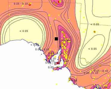
SA earthquake hazard map of region surrounding location marked by the black square. The yellow, brown, and red dots represent earthquakes (Geoscience Australia)
Figure 1b – Earthquake hazard map of region surrounding Site 40a whose location is marked by the black square. The yellow, brown, and red dots represent earthquakes (Geoscience Australia, 2003b).
The PIRSA earthquake maps (PIRSA, 2003) for years 2000 and 2001 show events to the west of Lake Torrens, and the EIS states “Activity west of the Torrens Hinge Zone, in the areas of the proposed repository … are likely to be related to blasting activities associated with mining at Olympic Dam and Mt Gunson” (my italics). However, I note the following: 1) not all these events are located at either Olympic Dam or Mt Gunson; 2) whether all these events are explosions should be explicitly determined by consulting the records of the respective licensed blasters; 3) mining activities can trigger seismic events; 4) Olympic Dam has a sophisticated seismic array to monitor earth movements at the mine (S. Eldridge, 2003, personal communication), and data from this array can be used to constrain the nature of local seismic sources, i.e., those within a hundred km.
Because of the historical paucity of seismograph stations, the occurrence and exact locations of earthquakes and their corresponding wave propagation characteristics in northern SA are not well known, and an intensive field campaign of earthquake monitoring has recently commenced “to improve estimates of seismic hazard in the region” (Geoscience Australia, 2003c).
In addition to the hazard posed by the known sources of seismic activity in the Flinders, there is the hazard posed by large intraplate earthquakes that could occur anywhere throughout the Australian craton, such as the 1987-1988 Tennant Creek earthquake sequence that included three magnitude 6+ events: “The Tennant Creek area had no history of earthquake activity before 1987.” (Seismology Research Centre, 1998). Cummins et al. (2003) argue that there are “large uncertainties … regarding an earthquake hazard map for Australia in which we can have complete confidence”, and they conclude, “Recent neotectonic investigations in areas of low topographic relief, for example, indicate that seismicity must be transitory in both space and time over large parts of Australia.”
Not only strong ground shaking, but also faulting and ground rupture can pose a significant hazard to the NRWR. Ground rupture such as that which damaged the gas pipeline during the earthquakes at Tennant Creek can damage waste containment structures. The 1992 ML 5.6-5.8 Little Skull Mountain Earthquake, whose epicenter is within 20 km of Yucca Mountain, Nevada, USA, a potential high-level NRWR, is the largest tectonic event that has occurred within 50 km of the site in historic time, and it has raised concerns about “coupled processes that may lead to the future release of radioactive material to the accessible environment.
A few examples of tectonically coupled processes are: co-seismic changes in the water table; changes in infiltration rates due to changes in fracture characteristics … ” (Whitney and Keefer, 2000). Similar abrupt changes in the water table were observed after the 1998 magnitude 5.3 Pymatuning earthquake in Pennsylvania, USA, and Fleeger et al. (1999) argued that these changes could be explained by faulting that fractured the aquitard and drained the aquifer. Faulting plays an important role in the natural occurrence of mound springs in the Great Artesian Basin (GAB) 200 km to the north (James Cook University, 2000).
The last sentence of the “Seismicity” section of the EIS is, “The repository and buildings would be designed in accordance with AS 1170.4-1993.” However, the abstract of the AS 1170.4-1993 states (Standards Australia, 2003):
Sets out data and procedures for determining minimum earthquake loads on structures and their components, and also minimum detailing requirements for structures. It does not consider related phenomena such as settlement, slides, subsidence, liquefaction or faulting in the immediate vicinity of a structure. It does not include nuclear reactors, dams, transmission towers, bridges, piers and wharves, which may require special consideration. The Standard is in limit states format. New earthquake maps are defined in terms of an acceleration coefficient instead of the zoning system used in the previous Standard AS 2121. Domestic structures are now included.
Therefore, AS 1170.4-1993 is essentially irrelevant to the design of the repository because the repository would clearly be one of those structures which “require special consideration.” The title, “Seismicity”, of this section about seismic hazard is itself a misnomer because the term seismicity refers to the temporal, spatial, and magnitude distribution of earthquakes but does not directly refer to their damaging effects.
Site 40a is not a site of minimal earthquake hazard. There is much uncertainty at present about the seismic hazard in the region, and much of the information that is available has not been included in the EIS. Furthermore, it is premature to attempt to evaluate the earthquake hazard until results are obtained from the recently commenced tectonic and seismic studies of the Flinders Ranges.
Most critically, the misunderstanding concerning AS 1170.4-1993 indicates that the EIS Study Team is not competent to evaluate seismic risk. The EIS Study Team did not include any geophysicists – it is essential that the EIS be approved by seismologists, and my Australian colleagues who are familiar with the Australian land are the ones to do that. In conclusion, as characterized by the Draft EIS, ARPANSA should not grant a license for the construction and operation of the NRWR at Site 40a.
Edward Cranswick
Bibliography
Cummins, P. R., Clark, D., Collins, C., Tuttle, M. P., and Van Arsdale, R. (2003). The potential for paleoliquefaction to contribute to Australia’s earthquake hazard map, Paleoseismology in the Twenty-first Century: A Global Perspective (Posters), The XVI INQUA Congress, Reno, Nevada, USA, July 25, 2003, <http://gsa.confex.com/gsa/inqu/finalprogram/abstract_55266.htm>.
Fleeger, G. M., Goode, D. J., Buckwalter, T. F., and Risser, D. W. (1999). Hydrologic Effects of the Pymatuning Earthquake of September 25, 1998, in Northwestern Pennsylvania, U.S. Geological Survey Reports: USGS WRIR 99-4170, August 1999, <http://wwwpah2o.er.usgs.gov/reports/wri99-4170/>, <http://pa.water.usgs.gov/reports/wrir_99-4170.pdf>.
Geoscience Australia (2003a). Media Release: Are the Flinders Ranges moving? Friday 2 May 2003, <http://www.agso.gov.au/media/releases/2003/2052003_gps.jsp>.
Geoscience Australia (2003b). National Datasets online GIS, <http://www.agso.gov.au/map/national/>
Geoscience Australia (2003c). Media Release: How big was that earthquake?, Wednesday 10 September 2003, <http://www.agso.gov.au/media/releases/2003/10092003_How_big.jsp>.
James Cook University (2000). Mound Springs, <http://www.tesag.jcu.edu.au/subjects/ge3402/_notes/Mound_Springs.html>
PIRSA (2003). YEARLY EARTHQUAKE REPORTS <http://www.pir.sa.gov.au/pages/minerals/earthquakes_new/eq_reports.htm>.
Seismology Research Centre (1998). 1988 January 22, Tennant Creek, <http://www.seis.com.au/EQ/EQ_info/1988_01.html>.
Standards Australia (2003). AS 1170.4-1993: Minimum design loads on structures (known as the SAA Loading Code) – Earthquake loads, <http://www.standards.com.au/Catalogue/script/Details.asp?DocN=stds000010445>
Whitney, J. W., and Keefer, W. R. (2000). Geologic and Geophysical Characterization Studies of Yucca Mountain, Nevada, A Potential High-Level Radioactive-Waste Repository, U.S. Geological Survey Digital Data Series 58, <http://pubs.usgs.gov/dds/2000/dds-058/>.
Discover more from Coober Pedy Regional Times
Subscribe to get the latest posts sent to your email.
Categories: GENERAL News
