
Geoscientists identify seismic activity in Southern Australia including the Flinders Ranges
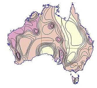
Earthquake Hazzard Map of Australia
Australia is not as geologically stable as many think. Despite popular belief, Australia is a geologically active continent with moving fault-lines, regular seismic activity, and a long history of mountain making, said internationally respected geologist, Associate Professor Malcolm Wallace from the School of Earth Sciences at the University of Melbourne.
We have discovered substantial evidence of ancient and current mountain building on this continent, and seismic activity which commenced 10 million years ago and continues to this day,” Associate Professor Wallace said.
“Two separate geological studies have concluded that an area from Adelaide to south-east Victoria is seismically active and the next ‘big one’ could endanger lives and infrastructure”.
“There are numerous young faultlines weaving their way across southern Australia, including one that goes right around the perimeter of Adelaide. There are also young faultlines running through the Mornington Peninsula outside Melbourne, the Strzelecki Ranges in Victoria and the Flinders Ranges in South Australia.
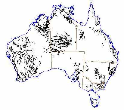
Fault Lines Located in Australia Map data source courtesy : Geoscience Australia
The University of Melbourne geologists have uncovered evidence that parts of South-eastern Australia recently stirred from their geological slumber and are in an active mountain building phase. These mountains are being shaped by earthquakes, some reaching greater than 6 on the Richter scale.
Submission: Seismic hazards SA
[The area between Quorn and Leigh Creek has the highest number of seismic events (considered to be related to zones of crustal weakness)]
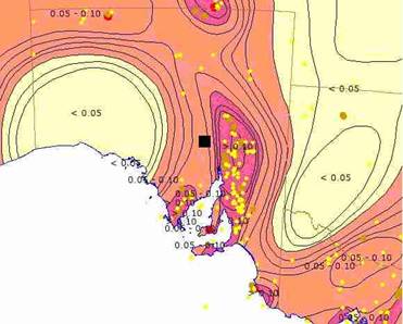
SA earthquake hazard map of region surrounding location marked by the black square. The yellow, brown, and red dots represent earthquakes (Geoscience Australia)
“Their seismic activity is generated by tectonic plates pushing up against each other on a daily basis, so it is critically important that scientists and emergency management agencies know of their whereabouts and the potential risks they pose – this is where geoscientists play a crucial role.”
“Some faults around Adelaide have moved slabs of the continent up to 30 metres in the last one million years,” says ARC Professorial Fellow, Mike Sandiford.
“When these big quakes reoccur, they have the potential to cause catastrophic damage to cities such as Melbourne, Adelaide, and the La Trobe Valley area, which straddle some of these major faults lines,” says Professor Mike Sandiford also from the School of Earth Sciences at the University of Melbourne, who conducted one of the studies.
Possibly, the most dramatic indication of this geological stirring, which the studies estimate began suddenly about ten million years ago, can be found in the landscape of the Mount Lofty Ranges near Adelaide.
“A typical earthquake of magnitude 6.0 might produce a displacement of about one metre. Thirty metres is equivalent to 30-50 big earthquakes in the last million years,” he says.
Other areas of intense mountain building have been around Victoria’s Otway Ranges, Mornington Peninsula and Strzeleckis. In some of these areas, similar uplift and erosion over the last 10 million years have thrust chunks of Australia upwards in the order of one kilometre.

The big earthquake still building South East Australia Epicentres of Australian earthquakes in the period 1859 to 1992 with magnitudes of ML4 or greater.(Illustration courtesy AGSO)
Tectonic movements have pushed the Otways 250 metres higher in the last three million years, and The Selwyn fault, which runs from Mt Martha, on Victoria’s Mornington Peninsula, east to the Dandenong Ranges has possibly produced six metres of uplift in the last 100,000 years.
“This is potentially six big earthquakes,” says Sandiford. “We are still trying to determine the slip rates along these fault lines, but our evidence so far suggests that we should expect, on any one of the major faults, a large earthquake every 10-20,000 years. The estimated return period of a quake greater than 6.0 in south-east Australia is about 30 years, but none have been recorded in the last 100 years,” he says.
Associate Professor Malcolm Wallace has undertaken significant research on the environmental and climatic evolution of the southern Australian margin. His research on greenhouse/icehouse climate and environmental evolution of Victoria for the last 80 million years has formed an important geological analogue for future climate change in Victoria.
Associate Professor Wallace was the recipient of the prestigious Geological Society of Australia (Victoria Division) Selwyn Medal for 2008. The Medal, named in honour of Sir Alfred Selwyn, an eminent Victorian pioneering geologist and founder of the Geological Survey of Victoria. recognises significant ongoing or former contributions of high calibre to any field of Victorian geology.
Induced seismicity – Wikipedia
Related Posts
The risk of volcanic eruption in mainland Australia E. B. Joyce (CSIRO)
Abstract
The young volcanoes of the Australian mainland are made up of the Newer Volcanic Province of Victoria and southeast South Australia (NVP), and a number of separate provinces in far north Queensland.
These volcanic fields are similar in age, and in their numerous scattered scoria and lava cones, extensive basalt flows, and maar/tuff ring eruptions of phreatic origin.
Australian volcanologists and seismologists now agree that youthful ages imply the possibility of further activity.
Post Mortem on Solomon Islands 8.1 Earthquake/Tsunami of 2007
By Gary Robbins, UNION-TRIBUNE STAFF WRITER
NASA report:
The massive magnitude 8.1 earthquake that jolted the Solomon Islands on April 1, 2007, permanently changed the shoreline on Ranongga Island, west of the epicenter. New beach was added to the western shore of the island when the earthquake lifted the island as much as three meters, exposing near-shore coral reefs, (Australian Broadcasting Corporation).
NASA: The Earth split like a zipper.
USGS summary:
At least 40 people killed, an undetermined number missing and several villages destroyed by the earthquake and tsunami. About 300 homes, schools and a hospital were destroyed at Sasamunga and about 500 houses were damaged at Gizo….
The latest Daily Live World Seismic activity Reports
Could Exxon-Mobil Works Have Tripped Indonesian Tsunami?
by Paul Noel, JAH, Sterling D. Allan and Mary-Sue Halliburton
Geology of South Australia Volcanic Eruption in Australia (Images)
Discover more from Coober Pedy Regional Times
Subscribe to get the latest posts sent to your email.
Categories: COPLEY/FLINDERS News & Events

Unexpected earthquake in Newcastle NSW Australia (near Sydney)
http://www.metacafe.com/watch/yt-lqwXKjOL4C8/newcastle_earthquake/
I live in Adelaide and last year in April 2010 experience my first earthquake be it only 3.7 on the rictar scale. I would like to know how likely is it that we will get a major earthquake like the ones that devastated China or America or even as recent as New Zealand 6.3
Best regards
Heather Elliott
Dear Heather,
I also live in Adelaide. The 2010 earthquake you experienced was probably the first that you actually felt even though tremors occur through the Adelaide and the surrounding region all the time, usually around 2 on the Richter scale, particularly around the Flinders Ranges often once a week. These tremors are usually not felt as far as Adelaide.
I remember feeling a tremor in the mid-90’s which was just enough to notice liquor bottles and glasses shaking on the bar. The epicentre was further north near Hawker.
Because we do not live near the edge of a tectonic plate, Adelaide is unlikely to experience earthquakes greater than 4 or 5 on the Richter scale. We do, however, live near faultlines that create the Adelaide Hills and Flinders Ranges that are constantly pushing the hills against each other all the time, which is why tremors up to 4 on the Richter scale can happen any time but are unlikely to cause much damge.
Mother Nature is unpredictable, however, so nothing is impossible! All we can do is continue to monitor seismic activity around the globe and predict future tremors using the limited information we have.
Hope this information helps.
Regards,
Adam Hodgson.
I live in Moonbi NSW Australia Which is 20 k’s From Tamworth NSW.
I heard the earth goes through a very strong magnetic field every 2-3oo thousand years and this is what causes big earthquakes and catastropic storms and aolar flares is this right.
Yours Faithfully
Frank Lee
@Frank Lee Moonbi (March 14, 2011) Here is a link/short excerpt to Paleomagnetism which you might find helpful. This could lead to further research. There is also a link/excerpt to the geology of the Tamworth including Moonbi, your home town. CPRT.
Paleomagnetism
As noted earlier, plate tectonics brings together numerous areas of study in the geologic sciences that developed independently but which came to be seen as having similar roots and explanations. Among these disciplines is paleomagnetism, an area of historical geology devoted to studying the direction and intensity of magnetic fields in the past, as discerned from the residual magnetization of rocks.
Earth has a complex magnetic field whose principal source appears to be the molten iron of the outer core.
http://www.answers.com/topic/plate-tectonics
The Tamworth district occurs across one of eastern New South Wales’ most significant crustal fractures, the Peel Fault. This major fault is developed for several hundred kilometres from Forster on the coast, to Warialda in the north. The Peel Fault has been active for more than 350 million years. Its presence is marked by a dramatic change in the rock types on either side, sometimes by the presence of serpentinite (serpentine), and by a prominent escarpment.
Click to access Tamworth_area_tours.pdf
Were thinking of leaving the Gladstone area and moving to Maleny, has there been any earthquake activity in or around this area.
Regards
This is the most acurate website for SA earthquakes
http://www.ga.gov.au/bin/listQuakes
I love the web site, it is very informative.
I live in East Gippsland Alpine Rangers near Mt Hotham and was wondering if there is a chance of an earth quake in my area. I have never felt the earth shake here. It is a beautiful place. It would be a pity to think of it being harmed.
Regards
Dawn
There are couple of links here to Mt Hotham area. Most towns are required to have an emergency response plan for earthquakes. Perhaps check with local SES and see if they have one.
Mt Hotham VIC
Magnitude: 5.7 (ML)
Depth: 24 km
Date and Time
UTC: 03 May 1966
http://www.ga.gov.au/earthquakes/getQuakeDetails.do?quakeId=58917
The junction of the Kancoona and Kiewa faults is in an area of poor outcrop and is also cut by the Tawonga Fault, so it is difficult to determine the relative timing of the two faults. However, the Kiewa Fault continues to the south past Mount Hotham, whereas the Kancoona Fault seems to stop, suggesting the Kancoona Fault is cut by the Kiewa Fault. It may be that the Cassilis Shear Zone (Fig. 41) is the displaced continuation of the Kancoona Fault.
Click to access geological_stop5.pdf
Thanks for this most informative website…
….Most people (in Queensland) do not realise that the State Govt. has not funded Siesmic monitoring for over ten years… Sure we have Geoscience Australia, and the USA doing it, also some monitoring by mining companies etc, but we don’t have a central point of State Government collection of ALL seismic activity… a lot of the monitors are unmanned (apparently) and (if functional) only switch on from magnitude 3. A few years ago I brought this to the notice of the State Govt, but got a pass-the-buck answer, telling me to refer to Geoscience Australia when I had given the Government the information I had already received from G.A. I sincerely hope that there never comes a time when they (the Govt.) wished they had done something more organised and possive… but, I won’t hold my breath.
… Keep up the good work…
Trish S.
Well it’s all kicking off. We live in warragul and this morning before lunch the house started to wobble from side to side for about 12 seconds. Felt another tremor an hour after. The kids were scared and so were we. It felt weird, very weird.
19 June 2012
5.2 magnitude 9km depth. Strongest point out near trafalgar Vic. Felt in Melbourne and most of gippsland. Strongest one in gippsland in 9years.
i beg to differ on the strongest earthquake in australia being in newcastle,it was in meckering western australia about 140kms east of perth in 1968, the magnitude was 6.8. at the time i was living in northam about 20kms west and it was huge,caused a lot of damage in the little town and in northam and was felt in perth,it was on a monday and it was a public holiday so there was no panic in the city centre.we had after shocks for years and they were quite terrifying. in 1979 or 1980 there was the the cadoux earthquake which was felt in perth where i was then living and that was scary as well. all weatherboard buildings in meckering stood after the 1968 e/quake but the brick buildings were badly damaged
The human-induced earthquakes comment by Johnny Kilroy omitted the capacity of HAARP to trigger earthquakes (man playing God!)
Adam Hodgson – there was a 5.6 magnitude earthquake in Adelaide back in 1954.
hi, i have lived in bunbury WA my whole life and never experienced any tectonic activity
Ive been feeling the earthquakes here in Margaret River for a few weeks now, from down at Lake Muir, could you provide me with a map of seismic zones in south west WA please ? Id love to see why im feeling them here 3 hours away