
“Was the Clark Shaft accident at the Olympic Dam mine preceded by a seismic event?”
A geophysicist who investigated earthquakes for the US Geological Survey for 22 years, says that the connection between mining and seismicity [earthquakes] is obscured in Australia, particularly the seismic hazard of the Olympic Dam mine.
In a communication [Memo] sent to various federal and state government ministers [and others] on Tuesday 22 May 2010, Seismologist Edward Cranswick discusses the 35-km-long, steeply dipping Mashers Fault which passes through the middle of the Olympic Dam ore body. A fault length which implies an earthquake of maximum about 7.
The same memo is available as a PDF
http://cranswick.net/Kalgoorlie/KalgoorlieEarthquakeOlympicDamMine.pdf
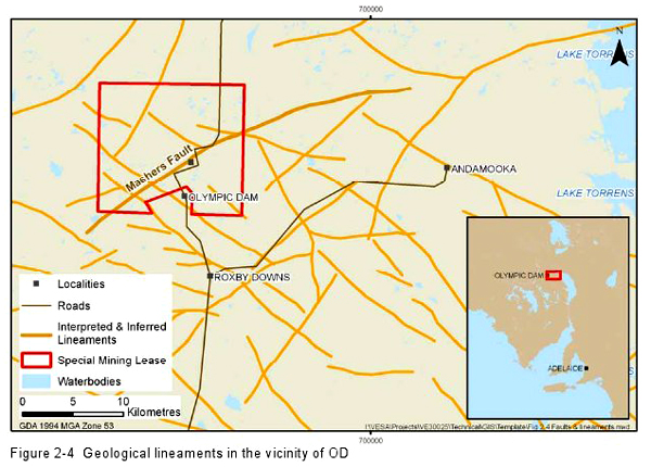
Mashers fault at Olympic Dam and other faults
Cranswick draws a comparison to the recent 20 APR 2010 magnitude 5 Kalgoorlie Earthquake which occurred in close proximity to the Kalgoorlie Super Pit mine as further evidence of the potential of open-pit mines to cause earthquakes in stable continental regions (SCR) such as Australia.
A further observation by Cranswick is that censoring of Australian lists of earthquakes and their corresponding source parameters, (i.e., time, location, depth, magnitude) has taken place.
“A plummeting ore skip in the main shaft [Clark Shaft] at Olympic Dam on 06 OCT 2009 was announced as reducing capacity at the mine to about 20 per cent for up to six months”, says Seismologist Edward Cranswick.
“No information about the cause of the accident has been released. However, the main shaft is ~2 km north-northwest of the surface expression of the Mashers Fault which dips towards it.
Was the accident preceded by a seismic event?” asks Edward Cranswick.
TO: The Hon Paul Holloway MLC, Government of South Australia
FROM: Edward Cranswick
CC: DPLG:Public Submissions
CC: Federal Environment Minister Peter Garrett, and others
DATE: Tuesday 25 MAY 2010
SUBJECT: The Kalgoorlie Earthquake and the Proposed Olympic Dam Mine Expansion
BHP Billiton has proposed to dig the largest open-pit mine on the Earth at Olympic Dam, 4.1 km long, 3.5 km wide, 1 km deep. As a geophysicist who investigated earthquakes for the US Geological Survey for 22 years [1], I strongly criticised BHP’s Olympic Dam Expansion Draft Environmental Impact Statement 2009 (ODXdEIS) [2] because it omitted consideration of seismicity, i.e., rockbursts or earthquakes, caused by open-pit mining, despite the fact that seismic hazard is well-known in the Australian mining industry (Hudyma et al. 2003 [3], Kalgoorlie Consolidated Gold Mines (KCGM) [4]). The recent Kalgoorlie Earthquake emphasises the probability and consequences of these seismic events as mines grow larger and deeper – the ODXdEIS needs to be re-evaluated because it does not address this issue at all. I discuss the connection between mining and seismicity and how it is obscured in Australia, particularly the seismic hazard of the Olympic Dam mine, and I make recommendations about these matters.
![]()
The 20 APR 2010 magnitude 5 Kalgoorlie Earthquake occurred in close proximity to the Kalgoorlie Super Pit mine (see figure above) [5]. This seismic event is further evidence of the potential of open-pit mines to cause earthquakes in stable continental regions (SCR) such as Australia as discussed in the paper, Mashers Fault and the Seismicity Anticipated to be Stimulated by the Proposed Open Pit Mine at Olympic Dam (Cranswick 2009) [6], I presented at the Australian Earthquake Engineering Society (AEES) in December 2009 in Newcastle, NSW [7].
On 04 DEC 2009, I emailed you a pre-print of my paper that you kindly acknowledged in a letter to me dated 15 DEC 2009 in which you noted that one of your departments, Primary Industries and Resources (PIRSA), would have a representative at the AEES conference. Previously, on 07 AUG 2009, I had made a Public Submission to your office about earthquake hazard&risk in response to the ODXdEIS, Seismicity anticipated to be stimulated by BHP’s proposed open-pit mine at Olympic Dam [8].
The Kalgoorlie Super Pit [9], with the dimensions 4 x 1.5 x 0.65 km (2.5 x 1.3 x 0.2 km, 12 SEP 2004, Google Maps [10]), is the largest open-pit mine in Australia, and according to the earthquake location of Kevin McCue (personal communication 2010), the Kalgoorlie Earthquake occurred near the Earth’s surface, i.e., at zero depth, about 2-3 km south-west of the pit. A former seismologist with Geoscience Australia, Victor Dent, said, “I think the stress was changed by the digging of the Super Pit and that predisposed the area to an earthquake.” [11].
The relationship between mining, stress, and rockbursts (a rock burst is “the significant damage caused to underground excavations by a seismic event”) in mines has been long recognised by mining engineers – indeed, it is one of their principal concerns. Furthermore, Kalgoorlie has a long history of seismic activity induced by mining – Ortlepp (2005) [12], a rock engineer for 33 years in the deep mines of South Africa and organiser of the series of international symposia founded in 1982, Rockbursts and Seismicity in Mines (RaSiM), discusses this seismic hazard:
“In Australia, rockbursting was first experienced as a significant but relatively infrequent problem in the Kalgoorlie district in the early part of the last [20th] century.
During the last decade of the century [1990s], as the extraction of the deepest massive orebodies of the Mount Charlotte mine peaked, several very large mining-induced tremors were experienced. Six seismic events between ML 2.5 and ML 4.3 (Richter scale) were recorded”
Based on the 72 mines that responded to their 148-question survey circulated to 135 mines in 18 countries, Hudyma and Potvin (2004) [13] concluded: “The incidence of high seismic hazard appears to be somewhat greater in western Australia compared with underground, mechanized, hardrock mines elsewhere in the world.”
There are reports from other stable continental regions of earthquakes triggered/induced by mines or other human activities (trigger: the fault is already near the breaking point and needs only a small stress change to fail). In the Kaap-Vaal craton in South Africa, only 8 of the 378 magnitude 3.5-4 earthquakes recorded in 50 years were “natural” i.e., more than 30 km away from mining activity (Otlepp 2005); hence, 98% were near mines. In northeastern United States, one third of the earthquakes greater than magnitude 3 during the period 1971-2003 were “human triggered”, mostly by quarries or fluid injection (Seeber et al. 2004) [14]. By contrast, the Australian story seems to be that earthquakes can happen anywhere in Australia except at mines, and when they do happen at mines, it’s just coincidence – notable exceptions to this story are seismological papers about mining induced seismicity, e.g., McKavanagh et al. (1995) [15] and Gibson and Peck (2006) [16].
There has often been an implicit, if not intentional, censoring of Australian earthquake catalogues (lists of earthquakes and their corresponding source parameters, i.e., time, location, depth, magnitude) compiled by regional and national seismograph networks because seismic events in the vicinity of mines are frequently discarded under the assumption that these events are explosions.
However, comparison with the South African data cited above suggests that some of these discarded events may have been earthquakes, either “natural” or those triggered/induced by the mining process – important information has been lost. Some of these events may have been very well recorded by microseismic monitoring systems within mines but that information can be difficult to access – BHP Billiton at Olympic Dam is exempt from Freedom of Information Act 1991 (Burdon 2006) [17].
Cranswick (2009) discussed three earthquakes triggered by open-pit mining, and now there has been another even larger earthquake at Kalgoorlie within about a pit’s length of the Super Pit – maybe it’s just coincidence … the KCGM mine management might know – do a search for ‘earthquake’ on their website .
The proposed 4.1 x 3.4 x 1 km open-pit at Olympic Dam would be much deeper than the Super Pit is now and several times the volume, and it would be excavated from rock subjected to high horizontal EW compressive stresses (~43 MPa at 1 km depth, Bunger et al. 2008 [18]).
Traditionally, underground mines are deeper, and therefore, more seismically hazardous than shallow open pits, but the proposed pit at Olympic Dam will be as deep as the underground mine it replaces. Based on the dimensions of the open-pit, the results of McGarr et al. (2002) [19] suggest an earthquake of maximum magnitude 4-6 could occur.
The 35-km-long, steeply dipping Mashers Fault passes through the middle of the Olympic Dam ore body that is to be mined – that fault length implies an earthquake of maximum magnitude about 7.
(Wells and Coppersmith 1994) [20]. Cranswick (2009) discusses Australian earthquakes in the magnitude range 6-7 during the last half century that produced fault scarps more than 1 m high and more than 10 km long. At Olympic Dam, such scarps and the strong groundmotions generated by the corresponding earthquakes could severely damage the 9 Tailings Storage Facilities (TSFs, i.e., square tailings dams, 2 x 2 km, and 65 m high) that will be built to contain gigatons of hazardous tailings.
Bores in the 100-500-m-wide Mashers Fault zone near the mine have high fluid flows (ODXdEIS), and Ito and Zoback (2000) [21] find that, “critically-stressed faults in the crust are also the most permeable faults”; hence, Mashers Fault may be critically stressed. More recently at Olympic Dam, ” damage from a plummeting ore skip in its main shaft [06 OCT 2009] is expected to reduce capacity to about 20 per cent for up to six months” (The Australian 21OCT2009) [22], but no information about the cause of the accident has been released – the main shaft is ~2 km north-northwest of the surface expression of the Mashers Fault which dips towards it. Was the accident preceded by a seismic event?
In their paper, An Engineering Approach to Seismic Risk Management in Hardrock Mines, Hudyma and Potvin (2009) [23] state: “The problem of mining-induced seismicity in hardrock mines has become significant as underground mines from around the world are pushing production to deeper levels.
At many mines, the risk associated with large seismic events and rockburst damage must be managed to ensure the safety of mine workers and minimise production losses.”
Ortlepp (2005) concludes: “It is to be hoped that large mining corporations and mine owners will also see the light and realise that it is ultimately in the best interests of all the stakeholders that the spectre of the rockburst hazard must be further exposed and eventually eliminated.”
So here’s the picture – on the surface, mining management & seismologists are not talking about earthquakes & mining – meanwhile, down in the mine, seismologists and the rest of the shift are worrying about when the next rockburst will happen as management tells them to go deeper & deeper …
It is absurd – irrational, unscrupulously & tragically dishonest and unprofessional – that the ODXdEIS for the proposed largest open-pit mine on Earth does not address the principal hazard to digging that mine, triggered/induced seismicity and rockbursts. The latter term does not appear once in the 4,600 pages of the ODXdEIS and its appendices. This omission echoes the Washington Post
(05 MAY 2010) headline , ” U.S. exempted BP’s Gulf of Mexico drilling from environmental impact study ” [24], about the world’s worst oil spill and environmental catastrophe. The ODXdEIS purports to predict the water depth in the open-pit 3,000 years from now (see figure below) [25] but does not mention any earthquakes at the mine during that same period.

No decision should be made concerning the ODXdEIS until specific new investigations are undertaken at Olympic Dam and published – made available to the public – regarding the seismic hazard of proposed open-pit and the seismotectonic potential of the Mashers Fault.
These investigations of the Mashers Fault and vicinity would be conducted by independent teams that each focused on one of the following tasks: paleoseismology, i.e., evidence of previous fault movement; a microearthquake survey done in conjunction with the existing mine-wide microseismic monitoring system; a search of regional & national seismograph network data to recover all records of seismic events near mines (within 30 km), identification of sources, i.e., blasts or earthquakes, confirmed by mine blasting records; geomechanical analysis of in situ stress, pore pressure, borehole data, etc., to estimate Coulomb stress change (King et al. 1994) [26] on the Mashers Fault in response to excavation of the open-pit; geophysical analysis of gravity & magnetics to determine regional structure related to Mashers Fault.
An independent group of mining geologists, geomechanical engineers and mining seismologists would integrate the reports from the teams and write an overview, but all reports would be released in full as appendices. Much of this work has undoubtedly already been done – it needs to be released to the public and made available from a SA government website.
The majority of Australia’s foreign exchange comes from mining, and mining is already the most hazardous industry in Australia [27]. As mining activity increases, seismic activity increases, and the amount of toxic tailings from the mines that must be safely contained increases – both seismic hazard & risk increase. Following the recent example, ” U.S. to Split Up Agency Policing the Oil Industry ” (New York Times 11MAY2010) [28], the responsibilities to promote and to regulate mining, both now done by the one South Australian government department, PIRSA, should be divided between two independent departments.
Edward Cranswick 12 Bowillia Ave Hawthorn, SA 5062, TEL: 08 8271 1309 email: e_cranswick@yahoo.com
REFERENCES
1. http://cranswick.net/Kalgoorlie/SeismoBioAEES20091115.pdf
2. http://www.bhpbilliton.com/bb/odxEis.jsp
3. Hudyma, M., D. Heal, and P. Mikula (2003). Seismic monitoring in mines – old technology – new Applications, Proceedings of 1st Australasian Ground Control in Mining Conference, UNSW/EAGCG, Sydney, Australia, Nov, ISBN 0 7334 2085.
4. http://www.kcgm.com.au/Environment/NoiseandVibration/SeismicMonitoring/tabid/132/Default.aspx>
5. http://cranswick.net/Kalgoorlie/GEI_KalgPitEQ_Mw5MPa10Caption.jpg
6. Cranswick, E. (2009). Mashers Fault and the seismicity anticipated to be stimulated by the proposed open-pit mine at Olympic Dam, in Kevin McCue and Sonja Lenz (eds.), Earthquake engineering in Australia: proceedings of the conference held by the Australian Earthquake Engineering Society in Newcastle, NSW, 11-13 December 2009. http://cranswick.net/MashersSeismicityAnticipatedOlympicDam/
7. http://www.aees.org.au/Conferences/2009/AEES/AEES.html
8. http://www.olympicdameis.sa.gov.au/html/submissions/public/CranswickEdward.pdf>
9. http://www.superpit.com.au/
10. http://maps.google.com.au/maps?hl=en&ie=UTF8&ll=-30.774547,121.501322&spn=0.02688,0.038581&t=h&z=15
11. http://au.news.yahoo.com/thewest/a/-/mp/7093175/super-pit-linked-to-quake-cause
12. Ortlepp, W.D. (2005) RaSiM comes of age—a review of the contribution to the understanding and control of mine rockbursts, inYves Potvin and Martin Hudyma (eds), Controlling Seismic Risk, 6th International Symposium on Rockburst and Seismicity in Mines Proceedings, Australia, 9-11MAR2005.
http://www.acg.uwa.edu.au/__data/page/2147/Ortlepp_keynote_web.pdf
13. Hudyma, M. and Potvin, Y.H. (2004). Seismic hazard in Western Australian mines, The Journal of The South African Institute of Mining and Metallurgy, Vol 104, No 5, pp 265-276.
14. Seeber, L., J.G. Armbruster and W-Y. Kim(2004). A fluid-injection-triggered earthquake sequence in Ashtabula, Ohio: implications for seismogenesis in stable continental regions,
Bulletin of the Seismological Society of America, Vol 94, No 1, pp 76–87.
15. McKavanagh, B., B. Boreham, K. McCue, G. Gibson, J. Hafner and G. Klenowski (1995). The CQU regional seismic network and applications to underground mining in central Queensland, Australia, Journal Pure and Applied Geophysics, Vol 145, No 1, pp 39-57.
16. Gibson, G. and Peck, W. (2006). Seismic hazards in underground mines, The Geological Society of Australia, Victoria Division, Evening Lecture, Thursday 26 October at 6.30 PM, Monash University, published in The Victorian Geologist, October 2006.
http://www.vic.gsa.org.au/newsletter/NLfiles/GSAVNL0610.pdf
17. Burdon, P. (2006). Above the law? Roxby Downs and BHP Billiton’s Legal Privileges, Website: Friends of the Earth, Adelaide. http://www.foe.org.au/antinuclear/issues/oz/u/roxby/indenture/indenture
18. Bunger, A., A.R. Jeffrey, G. Meyer, A. Larking, G. Jenke, G. Klee, and F. Rummel (2008). High horizontal stresses in SE-Australia derived from discing, breakouts and hydraulic fracturing to 2 km depth, Proceedings 3rd World Stress Map Conference, Potsdam, 15-17 October 2008.
http://sclilp.gfz-potsdam.de/fileadmin/SCLILP/user_upload/pdf/projects/proceedings.pdf
19. McGarr, A., D. Simpson and L. Seeber (2002). Case histories of induced and triggered Seismicity, International Handbook of Earthquake and Engineering Seismology 81A, pp 647– 661.
20. Wells, D.L. and Coppersmith, K.J. (1994). New empirical relationships among magnitude, rupture length, rupture width, rupture area, and surface displacement, Bulletin of the Seismological Society of America, Vol 84, No 4, pp 974-1002.
21. Ito, T., and Zoback, M.D. (2000). Fracture permeability and in situ stress to 7 km depth in the KTB scientific drillhole, Geophysical Research Letters, Vol 27, No 7, pp 1045-1048.
23. Hudyma, M. and Potvin, Y.H. (2009). An engineering approach to seismic risk management in hardrock mines, Rock Mechanics and Rock Engineering, Published online: 21 November 2009.
24. http://www.washingtonpost.com/wp-dyn/content/article/2010/05/04/AR2010050404118.html
25. http://cranswick.net/Kalgoorlie/ODXdEIS_Chap11SurfaceWaterFig11.7PredictedPitLake_Mashers.jpg
26. King, G.C.P., R.S. Stein and J. Lin (1994). Static Stress Changes and the Triggering of Earthquakes, Bulletin of the Seismological Society of America, Vol 84, No 3, pp 935-953.
http://www.ipgp.fr/~king/DownloadsVarious/1994/Big/King1994.pdf
28. http://www.nytimes.com/2010/05/12/us/12interior.html
Possibly Related Post
Pacific Northwest at risk for a mega earthquake
.
Discover more from Coober Pedy Regional Times
Subscribe to get the latest posts sent to your email.
Categories: GENERAL News

We’re interested in the uncanny observation by Cranswick that censoring of Australian lists of earthquakes and their corresponding source parameters etc takes place. At Andamooka we live on another intersecting faultline which they drilling geothermal into. Doesn’t anyone think this is a bit risky to human life in the area? We’ve never been told about this potential although the goverment is hell bent on controlling the future of our town. We’ve been put into a corner over a cunning takeover of Andamooka. We think they’ll ease us out so they won’t be held responsible for any impact arising from these problem earthquakes in the near future if the olympic dam expansion manages to slip through the safety net. Most of us oldies who went to school with the original tribe from around here, are seeing a new strain claiming ties to the country. I hope they don’t think we and plenty of others aren’t onto this!!
It’s a small relief that there are some honest scientists true to their profession as in the case of the Haiti warning in 2008. Is there any evidence that these warning are heeded, like this one at Olympic Dam now. Or are governments dancing to the shiny money and chancing with our lives? We live handy to this area and wonder how much instability the atomic bombs caused and now they want to quarry South Australia and make it a total sacrifice. Of course there will be massive earth quakes.
http://www.newscientist.com/ ….a group of scientists from the US and Jamaica warned in 2008 that a fault zone on the south side of the island – the Enriquillo-Plaintain Garden fault zone – presented a danger.
They predicted that a magnitude-7.2 earthquake would result if all of the strain along the fault “is released in a single event today”, according to the abstract the team presented at the 18th Caribbean Geological Conference.
The earthquake is the worst that has affected the Haiti region in two centuries and around 3 million people are likely to have been “severely shaken” by the earthquake, the BBC reports. A United States Geological Survey “shakemap”……shows the intensity and strength of ground shaking.
The quake erupted about 16 kilometres south-west of the country’s capital, Port-au-Prince, and at a depth of 10 kilometres. Powerful aftershocks – 32 at the latest count – continue to affect the region.
GROUND REPORT….with respect to the monumental earthquake that occurred recently in Haiti, the largest recorded quake in the region for at least this past half century, a fundamental question has been posed by many as to the degree and impact of this particular quake taken in conjunction with the Asian tsunami which occurred several years ago.
North Korea has actively been involved in testing its nuclear capability and quite recently. France conducted such tests regularly and routinely within the South Pacific for literally decades, merely discontinuing the practice in 1996 after many Tahitian islanders had been affected by the radioactivity which was the result of those underground and above ground tests.
Literally thousands of underground tests were conducted after World War II until the mid to late 1990’s.
Most of such testing was done underground. Two of the largest faultlines are near Haiti, and near San Francisco in the United States.
http://www.groundreport.com/Business/Past-Nuclear-Testing-Contributing-To-Natural-Disas_12/2918054 Josh
Would you say the two magnitude 3 earthquakes/tremors within the last year in Adelaide were caused by the Olympic Dam?
Edward Cranswick says, “I do not think Adelaide’s two M3’s were “caused” by Olympic Dam, but these events were caused by a stress system of horizontal compression responsible for the recent uplift of the Flinders & Adelaide Hills and which extends over much of Australia, making the continent prone to earthquakes where it has been somehow weakened”.